 Sign In
 0 Items (
 Search


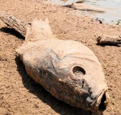 As we daily watch disturbing images of a dry Darling River, parched Menindee Lakes, millions of dead fish and outback towns running out of drinkable water, both bush and city are screaming ‘Why?’ Who is responsible and how can they be meted the punishment they deserve? Those questions, while understandable, are not rational — and worse, they obscure the key factors driving the demise of a productive river system.
But before we look more closely at why and how these unacceptable events have occurred, we need to put to rest some misconceptions about this river and recent claims made by Aboriginal people that the Darling was previously a “mighty river” that always flowed. Simply put, it wasn’t and never has been.
The first European eyes to see the Darling belonged to the explorers Stuart and Hume. That was in 1828, and recorded history tells us Menindee was bone dry at least 48 times up to 1960. It has only been since the commissioning of several dams on the tributaries of the Darling and the off-river Menindee Lakes storage in 1968 that the river has been kept flowing, successfully supplying fresh water to users along its great length. That remained the state of affairs until recently, when the system went from several flood events to the present parched disaster in a very short time.
The media have been plastered with sensationalist stories of water theft, political corruption, plus calls for the closure of Cubbie Station and even the jailing of cotton growers. Predictably, green fingers point at alleged collusion between corporate agriculture and politicians. All this is being articulated with a loud and noisy passion that fits neatly with the simplistic preconceptions of city dwellers, but it is mostly incorrect. If political opportunism could irrigate a field or supply bush towns the Darling system would be in flood. When those who promoted the policy that caused this problem blame others, as they are now doing in large part to save their political skins, what we are also seeing is hypocrisy that surges above and beyond all previous high-water marks.
So if the scapegoats listed above are not responsible, who is?
Start with management of the system, which changed markedly when the Turnbull-inspired Murray-Darling Basin Plan (MDBP) was introduced in details that most don’t appreciate. The first was that ownership of volumetric licenses to irrigate were removed from land that could be irrigated. These licenses were then available for purchase by green bureaucracies, speculators and investors. Irresponsibly, these licenses could then be bought and moved from one valley to another. Secondly, the NSW Government exacted from irrigators 15% of their licensed volumes and vested this water with the Department of Heritage and Environment. Other government agencies and indigenous groups were also allocated water from our, the people’s, storages.
The result has been that stored water previously and prudently kept to keep our rivers running and supplying basic needs in dry times has been squandered, sent pointlessly to the sea under the guise of “environmental flows”, “translucent flows”, “heritage flows” and “indigenous water”.
The prime example is the twice near-draining of Menindee Lakes for the dishonest purpose of “flushing” the lower Murray. This was flagrant waste of water and the reason Broken Hill ran out of water and is now reliant on a $500 million pipeline from the Murray.
The problems caused by over regulation of our river system, presently and vividly apparent on the Darling, are in fact spreading south. If not addressed it is likely the whole basin will be out of water by this time next year.
Not only is the Darling being killed, our food bowl and regional communities are bleeding to death because of the counterproductive MDB Plan and the NSW water-sharing plans. While politicians and governments continue to spurn the humility and honesty to recognise and admit that the present situation is caused by their legislated mess of overlapping bureaucracies the MDB Plan will remain catastrophically counterproductive.
The Darling is not being killed by Cubbie Station or any of the other scapegoats favoured by journalists, politicians and those ignorant voices arising from inner-city electorates. No, the answer is more simple than that: it is being killed by the governing class in Canberra and Sydney.
Ron Pike is a water consultant and third-generation irrigation farmer


Ron, reading this article yields great anger with Turnbull and others of his ilk who have absolutely no idea what they are or, in Turnbull’s case, were doing with the Murray Darling Basin. The whole water management system, let alone the energy sector, in Australia is being driven by people with no idea and yet they are in power and no sensible alternative is likely, especially not Labor and the Greens.
We have also been involved with flood irrigation and seen first-hand the adverse saltation effects on agricultural land.
The argument being pushed by politicians and corporatized farming interests that we need more water storages warrants more objective consideration.
A core information requirement for managing Australia’s water resources is knowledge of the spatial location, relationships and characteristics of the hydrological features: the catchments, streams, aquifers, storages, wetlands and man-made structures that make up the hydrological system.
Hitherto, water storage structures have generally been developed on political imperatives without adequate awareness of the criticality of HYDROLOGY pertaining to basins and catchments. Some have been successful enhancements of infrastructure, but others of potential riskiness.
In late 2008, the Bureau of Meteorology (BoM), in partnership with Geoscience Australia, CSIRO and the Australian National University (ANU) commenced the development of the Australian Hydrological Geospatial Fabric (Geofabric).
The Geofabric is being developed to underpin the Australian Water Resources Information System (AWRIS) within a single, consistent, national geospatial framework for hydrological features.
Unfortunately; the agencies involved are very politicized with many influential entities brainwashed on so-called ‘climate change’ considerations.
Nevertheless; the hydrological data now being gathered is of the utmost importance in maintaining the natural balance in basin and catchment systems.
The Fitzroy River Basin is located in Central Queensland, Australia. Its catchment covers an area of 142,665 square kilometres, making it the largest river catchment flowing to the eastern coast of Australia.
From source to mouth, the Fitzroy River is joined by thirty-six tributaries including the Mackenzie River – with its tributaries the Nogoa River, Comet River, Isaac River and its tributary Connors River; and the Dawson River – which has two tributaries, the Don River and Dee River.[
The Fitzroy River catchment system has many weirs and dams, used for farming, mining and domestic consumption. In the Dawson River sub-catchment, the major reservoirs from source to mouth are the Glebe Weir, the Gyranda Weir, the Theodore Weir, the Moura Weir, the Callide Dam, and the Kroombit Dam. In the Mackenzie River sub-catchment, the major reservoirs are the Comet Weir, the Fairbairn Dam, the Theresa Creek Dam, the Bedford Weir, the Bingegang Weir, and the Tartrus Weir. In the main Fitzroy River sub-catchment the only reservoirs are the Eden Bann Weir and the Fitzroy River Barrage, with the latter capable of holding 61,000 megalitres to provide potable water to Rockhampton and surrounds.
About 30 percent of all precipitation becomes runoff with absorption of water diminished by land clearing.
Historically; Rockhampton was subject to major flooding events from this vast catchment system, but subsequent construction of a barrage separating fresh water and tidal salt water flows, river bank fortifications and downstream flood plain road and drainage enhancements have largely eliminated flood consequences within the urban area.
A major weather event occurred in April 2017 with the Fitzroy River near peak level for almost 2 weeks, but there was only minor nuisance flooding with effective traffic diversions (that the Rockhampton Regional Council have since buggered up with some ridiculous road junctions obstructions).
A basin or catchment system can be likened to a giant sponge. Evaporation notwithstanding, creating dams, weirs or other water storages upstream directly impacts on high volume water flow behaviour downstream.
Given the virtual absence of major flooding in Rockhampton in April 2017, the vast Fitzroy River Basin could be seen as being in delicate balance.
But now, politicians and corporatized farming interests are pushing for the development of another weir not far upstream from Rockhampton.
Without adequate study of the potential hydrological consequences downstream, past major flooding risk to the Rockhampton urban area and surrounding district might be worsened.
Political thought bubble notions to build water storage facilities are fraught with potential adverse consequences, if regional basin/catchment hydrological effects are not paramount considerations.